The Dixie Fire, Northwest of Lake Tahoe and of the Beckwourth Fire, is now the largest in California at (update August 10) 488,000 acres, or 763 square miles, larger than Los Angeles at 503 square miles. It is now the second largest fire in California history. It has burned down the central district of the town of Greenville and 900 structures. It is now threatening 16,000 structures, and has displaced 30,000 people. It is in Butte, Lassen, and Tehama Counties, and is 25% contained. There are 6,000 personnel working on the fire. It is Northeast of Paradise, which was destroyed in 2018, the worst wildfire in California’s history.
The Beckwourth fire near Lake Tahoe in California is stabilized at 105,670 acres or 165 square miles.
The largest US wildfire is the Bootleg fire in Southern Oregon at 413,000 acres or 645 square miles.
Update July 28: the total acres burned this year in the US is 3 million acres, or 4,700 square miles. The over 70 currently burning wildfires have burned more than 1.5 million acres, or 2,350 square miles.
The total acres burned as of July 21 in Canada is 5.31 million acres, or 8,300 square miles. This is 177% times the US acres burned. Don’t blame the Eastern air pollution on the US alone.
Here is the updated to August 5 map of the Dixie fire from Inciweb.nwcg.gov. Greenville is at the edge on the middle of the East flank.

10 Day Progression of the Dixie Fire, 7/14 to 7/23. From light blue to dark red.

AirNow Map of Western Air Pollution from Western Fires, showing PM2.5.

PM2.5 measures particle air pollution of size 2.5 millimeters. The scale is in parts per million, ppm. The worst in the map in Southern Canada is purple of Very Unhealthy at 201-300 ppm. The Red around the Dixie and Beckwourth fires is Unhealthy from 151-200 ppm. Orange is Unhealthy for Sensitive Groups of 101-150 ppm, and Yellow is Moderate of 50-100 ppm.
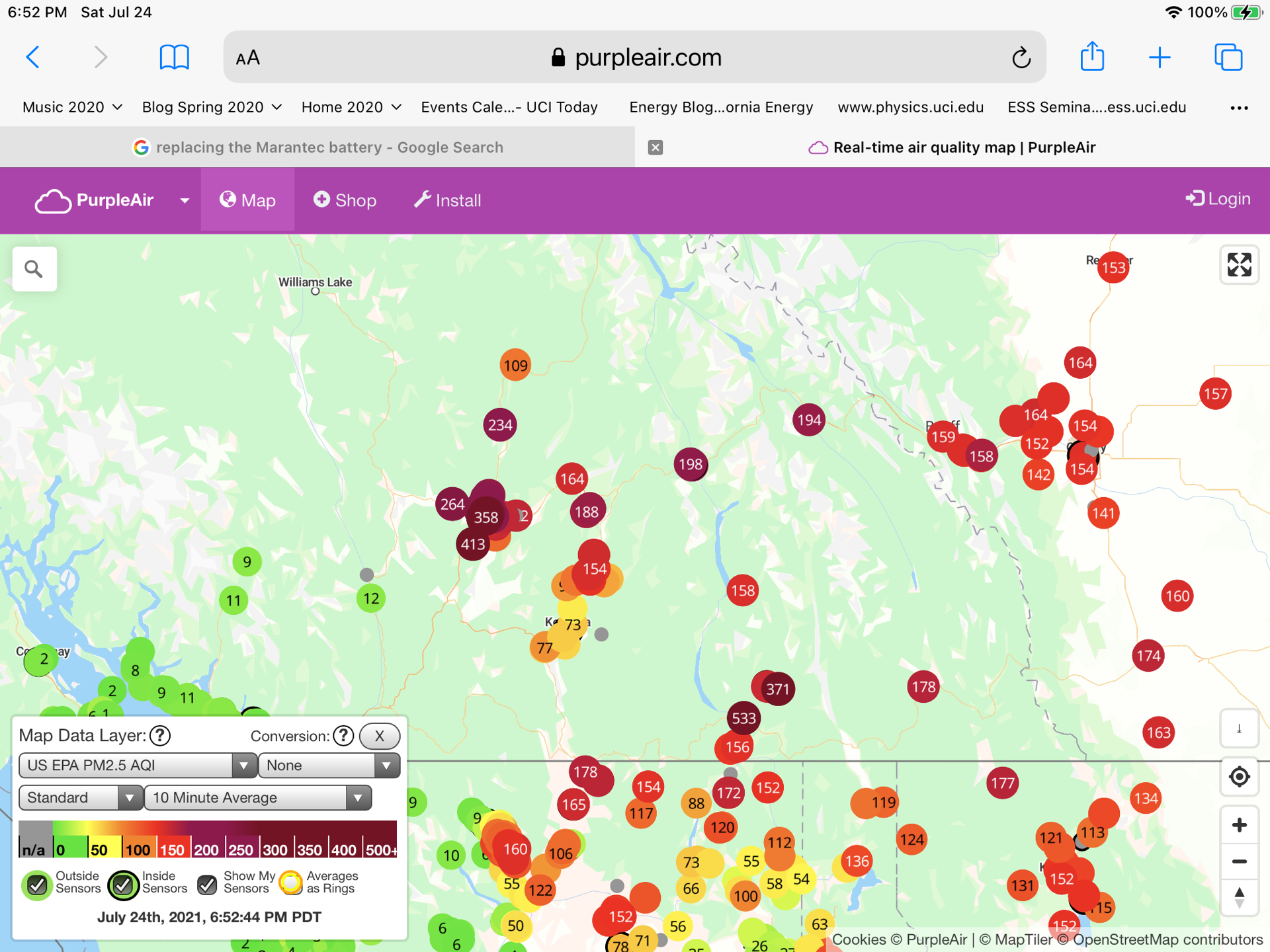
PurpleAir.com Air Pollution form Western Wildfires

This shows the actual readings of PurpleAir air quality detectors of PM2.5. The worst reading at the location of California fires is 662. The worst reading on the Southern Canada fires is 304.
The 365 reading in central USA is a single detector, and might be near an outdoor barbecue.
We add the PurpleAir closeup of the Northern California area of the Dixie and Beckwourth fires.

We now add a PurpleAir closeup of the Canadian forest fires with bad air near Banff and Kamloops.
From World’s Air Pollution waqi.com we see the August 7 Air Quality around the Dixie fire:
