

The downtown part of the town of Vienna, Virginia, is a study in juxtaposition. The main street, Maple Street, also happens to be VA Route 123, a major thoroughfare for Northern Virginia. Along Maple street, you will find well-worn family businesses next to major chain stores and small boutique restaurants facing fast-food restaurants on the other side of the street. One of Northern Virginia’s largest growing areas, and site of one of the United States’ largest shopping malls, Tysons, is just a few miles down the road and yet downtown Vienna still maintains a small town feel and charm. Church Street runs parallel to Maple (VA-123) and is lined with unique small businesses and delicious, one-of-a-kind restaurants. It is also home to Vienna’s historic district. Despite there being major office buildings and a giant shopping mall nearby, just behind Church Street are dozens of small, single family homes that give the it feeling of suburbia instead of a metropolitan center. Because of all of these opposing pieces, there are many forces that impact the downtown area of Vienna, Virginia.
FORCE ONE: TRAFFIC

A staple of life in Northern Virginia, traffic is everywhere, and Vienna is no different. There is consistently vehicle traffic through the main street (Maple Street), which also happens to a main highway (VA-123). This traffic will then cause overflow onto Church street, since it runs parallel to VA-123. During rush hours (we have multiple here), one will find both Maple and Church street packed full of commuters trying to get home. Even on weekends, there is still a fair amount of traffic through both streets. In addition to vehicular traffic, there is also the foot traffic of shoppers walking up and down the streets.
FORCE TWO: W & OD TRAIL

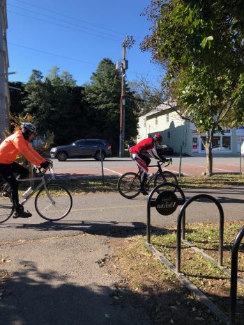
The Washington and Old Dominion (W & OD) Trail runs directly through the downtown strip of Vienna along Maple Street (source). This trail is heavily used by cyclists as well as joggers and their presence is a large force on the area. The highway of VA-123 actually contains a stop light specifically for the trail crossing and it is not unusual to be stopped there for quite some time as bikers and joggers pass through. Because of the trail, there are also multiple bike stores along the main street and nearby, and a brewery, Caboose Brewing, that is specifically stationed along the trail for thirsty cyclists. It is impossible to experience downtown Vienna without being impacted by the W & OD.
FORCE THREE: HISTORY

As mentioned above, the “historic district” for the town of Vienna resides on Church Street and certainly has a large impact on the area. Everywhere you go, there are signs announcing it as the historic district and plaques describing various historical sites, including the original Vienna library from 1897 and Freeman Store and Museum from 1859 (source). With so many markers and historic sites in just a small area, it is clearly that the history of Vienna is very influential on its current existence.

FORCE FOUR: COMMUNITY


Another prevalent force in downtown Vienna is the community. Church Street has multiple signs and notices for community events going on, including a “Tiny Tots Holiday Concert” at the local high school. There is also a “Children’s Discovery Garden” that is maintained by the local gardening club. There are frequently festivals and events going on along the street as well, such as an Oktoberfest, a Halloween parade, and a town celebration (source). It is hard to walk down the street and not see a sign for a local community event or an invitation to join a new local group.
FORCE FIVE: ARCHITECTURE


Perhaps a slightly more subtle force than the others, the architecture of downtown Vienna, especially along Church Street is unique and affects the overall feeling of the space. There are several older, more historic buildings mixed in with newer, red brick buildings. What I find to be most unusual is that several of the buildings have different facades and coverings than just plain brick or wood. There is the clock shop with its wooden shingles and oddly angled roof, and then Bazin’s restaurant has a distinctive red face with large windows that set it apart from the other buildings nearby. Whether it be from the 1800’s or the 2000’s, there is a very eclectic mix of architecture on Church Street that lends downtown Vienna much of its unique flavor.
MAPS


PART 3: FINAL MAP


As you can see, there were several iterations of my map. I decided to remove the “Community” force because I did not feel it fit in well with the rest of the narrative my map was telling – how the area shown has grown over the past 200 years. I still included the traffic because while it may not directly relate to any of the history of the area, I do think that it shows that now the majority of traffic and activity is not along the road where all of the historic buildings are centered. I also took my cohort’s suggestions into account and lightened the background, removed the white outlines, and added numbers and names for the historical sites. I had also added the dates those historical sites were built, but then removed it because I felt it made the legend look too cluttered and was not entirely necessary since there is color coding to at least show the era in which the buildings were created. Overall, I ended up enjoying this project and the process much more than I expected. I think this is in large part due to the fact that it was split up into more manageable parts, so I did not feel overwhelmed, and I also appreciated all of the critiques and comments I got as well as being able to look at my classmates’ work. This is the first map I have ever created and likely my most detailed piece done in Illustrator, so it was great to get to work on my skills there as well!
Hey Gillian,
You chose some really interesting and unique forces to map! It looks like the center of your map is the heart of where the historical sites are in this area, and potentially the green space (which I assume to be a park) was built around the main historical sites in order to preserve/memorialize them. It also appears that development grew out from around the main historical sites. Older buildings are closer to the center while the newest buildings are further out along the edges of your map. To me, traffic is an interesting force to have included. I would have thought the heavier traffic would have been along the road going through the heart of the area instead of further out where there are less buildings (unless I’m reading the map incorrectly and yellow is heavy traffic and red if light traffic). Regardless, it’s an interesting insight!
Hi Gillian,
I love that you’ve mapped the age of buildings. That’s a really cool idea and I’m glad you ran with it! Here are some of my initial thoughts on your combined map:
1. Consider ditching the white outlines. Your map will feel less cluttered and have better readability if buildings and roads are represented with fills, rather than lines. (If you need help with this in Illustrator, lmk!)
2. I would actually reorder the “Building Date” part of the key and arrange them from oldest to newest, since you’re really emphasizing the historical relevance of your site. Maybe also think about changing your date ranges to something a little more standardized, like 1800-1899, 1900-1949, 1950-2000, 2000-present. This is the format and order I’d probably expect to see, as a user.
3. I’d love to know more about the historical sites! Maybe you can label them with little numbers inside the pin icon, then list the names in your key? Cassandra implemented this feature really well in her map– take a look for inspiration!
4. Have you included any historical residential buildings that might be in the area? What about historical sites that aren’t buildings, or places where significant moments in local history occurred?
Hey Gillian,
I really like the forces you chose! The gradient for traffic is great, and the historical architecture is a really intriguing force. And yep, as others have mentioned having a legend or some titles will help. A title like “Era built” over the 1800s, 1900s and 2000s would be helpful so my brain doesn’t have to work so hard 😛
Your map is really clear. I think decreasing the contrast as others have mentioned, by de-emphasizing the dark color of the buildings will help (unless you’re calling them out in a particular map).
Great work.
Hi Gillian,
I really enjoyed reading about your site in Virginia. It reminded me of my site, with the different historic buildings and traffic. They seem to share a lot in common. The old clock shop is really a very interesting looking building! I think you are missing a base map without any extra data on it, but that should be an easy fix. Also, there seems to be some formatting issues with your post, under Force Two. The text and imagery is shifted to one side, I can send you a screen shot if that helps. I like where you are taking this project. I look forward to see how you implement the new revisions discussed with the other Joseph.
Hey Gillian,
I really like that you used varied techniques to map your forces – using a gradient to show light vs heavy traffic, using different sized stars for community. I think a legend would help specify exactly what you’re depicting (does a larger star mean that space is larger, or does it mean the community event is more popular/prominent?). I’ll also be interested to see how you address the fact that the history forces are identical to the architecture forces from the 1800’s. My final suggestion is that you might want to consider lightening up the background to help make the colors really pop. I’m excited to see everything come together for your final map!
Thanks Joseph! Those are all really great (and helpful) suggestions! I did not even think that the stars would be interpreted in different ways, so I can see how I just assumed everyone would have the same interpretations as me, which is probably not something you necessarily want to do with a map! And thanks for the comment about lightening up the background, something felt off but I couldn’t quite put my finger on it. Thanks!
Hi Gillian,
I think it’s very interesting to include the historical forces as well as notable architecture. I’d be interested in understanding the different kinds of architecture and how that might correspond to specific historical places/events in Vienna. If you go this route, how do you plan on representing this?
Thanks!
Alex
Hey Alex! That is a really interesting idea – something I had not entirely considered before. It is definitely true that there are some buildings that have been around for hundreds of years and others that are within the past 10 years. I think a compare and contrast of these buildings, where they are, and what purposes they serve could be an interesting direction to take things. Perhaps a map with the different buildings colored differently depending on the time they were built? I think it would also be interesting to see the homes in the area and when they were built as well. Thanks for the great idea!